|
|
|
APSLEY LOCK PARKING
CONTROL SCHEME
Scope
This
document describes the proposed parking control scheme for the Apsley Lock
development in terms of zoning, signage, permits and road markings.
The
Boards of the three companies have been mandated with the task of managing the
development, i.e. Belswains Lane Residents Association (BLRA), Apsley Mills
(Blocks A, B & D) Flat Management Co. Ltd. (ABD) and Apsley Mills (Blocks
E, F & G) Flat Management Co. Ltd. (EFG).
The
scheme has been developed by a sub-committee of the joints Boards of the three
companies with each company being represented on the sub-committee.
The
joint Boards have felt it necessary to implement such a scheme:
It
has been agreed by the joint Boards that any such parking control scheme, and
subsequent penalties/sanctions, must be implemented simultaneously by all three
companies across the development, excluding the areas administered by the
Metropolitan Housing Trust.
The
scheme, as described, does not mention penalties/sanctions for non-compliance
with the scheme. In the first instance the scheme would allow car parking to be
monitored so that a more accurate view of the problems could be formed and
assessed. However, when implemented, the necessary control for
penalties/sanctions, of whatever kind, to be implemented will be in place should
the joint Boards agree on the necessity for them.
The
Metropolitan Housing Trust (MHT) has implemented a clamping scheme for the
areas of the development which they administer. This is a completely separate
scheme to the one described in this document, however, MHT have indicated they
may join the scheme proposed herein once it is implemented.
Overview
This
proposal should be read in conjunction with overall and individual zone/block
& signage locations drawings based on the Legal Plan of the site, Fairview
New Homes Drawing No. FNH216 A/31 Rev. S.
The
parking control scheme divides the development into named areas which bring
together houses and apartments into logical groupings which may be considered zones
(houses) and blocks (apartments).
The
areas are:
|
Area
Name |
Description |
|
Zone
1 |
The
area immediately in front of the six garage block belonging to the houses on
Minoan Drive. |
|
Zone
2 |
Crown
Walk, Mulready Walk south of Imperial Way and all access roadways associated
with garages and parking bays for houses in Crown Walk and Mulready Walk. |
|
Zone
3 |
The
area associated with garages and parking bay access for the houses on Belswains
Lane and Evans Wharf. |
|
Zone
4 |
The
area associated with the garage and parking bays on Stephensons Wharf |
|
Block
ABD |
All
access ways and parking bays associated with Blocks A, B & D apartments
including the Marina and access roads to the East and West of the Marina. |
|
Block
BW |
The
two sets of ten parking bays belonging to British Waterways. |
|
Block
E |
The
access and parking bays associated with Block E apartments on Imperial Way. |
|
Block
F |
The
access and parking bays associated with Block F apartments on Minoan Drive. |
|
Block
G |
The
access and parking bays associated with Block G (Barge House) apartments on Evans
Wharf. |
Whilst
all houses have a garage, either integral or in a block, some have parking bays
on the garage ‘driveway’, whilst some have allocated parking bays either
immediately in front of the garage, or within a designated area a short
distance from the property.
In
certain instances, i.e. where the allocated bays are mixed with parking bays
for apartments, are identified with the plot number.
The
apartments have non-allocated bays associated with each block. These
unallocated bays are immediately adjacent to the apartment blocks to which they
belong.
The
parking control scheme includes appropriate signage for each zone/block as well
as general signs on both entrances to the development. The scheme does not
cover the roads that are to be adopted (See Road Adoption)
Visitor Parking
There
is no visitor parking provided in each Zone or Block. Unrestricted visitor
parking bays are provided in the following locations.
|
Location |
No. of Bays |
|
Mulready
Walk, north of the crossroads with Imperial Way/Evans Wharf |
2 |
|
Stephensons
Quay, either side of the main development entrance from Belswains Lane. |
8 |
|
Stephensons
Wharf, South side, either side of the junction with Stephensons Quay. |
22 |
The
boards are investigating the creation of visitor parking spaces on the estate.
In order for such bays to be created planning permission from Darcorum Council
would have to be granted. The Council will take into account central government
legislation and guide lines, local issues and the manner in which the parking
is managed on the estate (.i.e. whether garages are being used to park
vehicles). Only limited amount of additional parking spaces could be created.
Putting tarmac over areas of grass land will not be accepted by the council.
Therefore, the creation of a few more parking spaces will not alone resolve the
parking issues that currently exist.
Permits
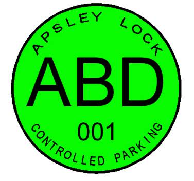
Permits
will be printed in light fast colours, each zone or block having a unique
colour. The permits will also carry a large zone/block identifier and a unique
identification number. The design of the parking permit is being finalised, but
it will along the lines detailed below.
The
permit will either be printed on self adhesive film or on holographic paper to
make duplication more difficult.
The
issue, distribution and maintenance of permit allocations will be carried out
by the Managing Agents who will set-up and maintain a register of permit numbers
against property addresses. If a permit is lost or not passed on by
tenants/owners when a property’s occupiers change, the assigned permit
number(s) will be cancelled and the appropriate number of new permits with new
identification numbers will be issued. The register will also record all
cancelled permits. Once a permit identification number is cancelled the number
will not be re-used.
There
will be a charge for the issuing if replacement permits to cover administration
and printing costs.
The
number of permits to be issued per property will be as follows:
|
Area Name |
No. of Permits |
|
Zone
1 |
2 |
|
Zone
2 |
2 |
|
Zone
3 |
2 |
|
Zone
4 |
2 |
|
Block
ABD |
2 |
|
Block
BW |
See
Note |
|
Block
E |
1 |
|
Block
F |
1 |
|
Block
G |
1 |
Note: For Zone BW British
Waterways will be issued with the number of permits they request, however they
will only be allowed to park in the designated parking bays within Block ABD.
For
houses which do not fall into a Zone, i.e. those whose allocated parking is within
their garage access area, no permits will be issued.
Certain
houses have three parking (2 parking bays and a garage) spaces. For these
houses three permits will be issued.
To
make the parking control scheme effective, all residents of the development must display the permits at all
times. The sub-committee recognises that there may be an issue with absentee
landlords not passing on permits to their tenants. This could be overcome by
posting the permits to the property address.
The
onus will be up to incoming tenants, landlords or new owners of properties to
apply to the Managing Agents for new permits if outgoing tenants or owners do
not leave the permits.
The
production and distribution costs of the permits will be met by BLRA.
Signage
The
wording and positioning of signs is important. They must be clear and unambiguous
and be sited such that there is no doubt as to the applicability of the
restrictions.
It
is proposed that two general signs be placed at each of the two entrances to
the development stating that it is a controlled parking area and giving the
times when the parking control scheme is in effect.
Individual
Zones and Blocks will have separate signs unless there is a common access point
in which case a joint Zone/Block sign will be used, e.g. Zone 4 and Block ABD.
The
clamping and parking control sings that are currently erected will be taken
down, with the exception of those relating to the MHT parking control scheme.
The
production and installation costs of the signs will be met by BLRA.
Timings
Even
a casual look around the development during weekdays (Monday to Friday) shows that
there is no parking problem. Most concerns have been expressed about evenings,
weekends and Bank Holidays.
Concerns
have also been expressed about tradesmen, health visitors and other parties not
being able to park on the development during the day. It is, therefore,
proposed to restrict the parking control scheme to:
This
will give visitors to properties unrestricted parking between 9am and 4pm
Monday to Friday.
As
the timings are display on the entrance signs only, they may easily be
adjusted.
Bay ‘T’ Marks
Many
parking bays are already marked with ‘T’ marks designating the limits of the
bays. Some ‘T’ marks are badly faded and need to be renewed.
Bollards
Bollards
will be placed in two locations on the site. At the end of Crown Walk and
Mulready Walk, where the rod way meets the grass areas and the footpaths that
led to the houses that are along the canal.
This is being done to prevent vehicular and pedestrian rights of way
(See below - Vehicular and Pedestrian Rights of Way).
Bays “T” Marks
Some
bays, particularly those in Zone 1 and Zone 2, are marked by a variation in the
colour of the block paving surface of the roads.
New
‘T’ marks will be required for Block E and Block F which have no bays marked.
The number of bays will be in accordance with the bays shown on the Legal Plan.
The
cost of new ‘T’ marks and renewal of existing ‘T’ marks will be met by the
relevant Flat Management Company.
Adoptable Roads
The
status of the adoptable areas shown on the Legal Plan is uncertain at this
time.
These
roads need to be adopted by the Highway Authority (for Hertfordshire this is
operated by Herts. County Council). Once a road is ready to be adopted then a
period of ‘Maintenance’, is entered into between Fairview and the Highway
Authority. This can last for up to 12 to 18 months before the roads are adopted
by the Highway Agency.
During
the Maintenance Period, Fairview maintain ownership of the adoptable areas and
responsible for the repair and maintenance of the areas. After adoption the
Highway Authority will assume the repair and maintenance of these areas.
Once
the road has been adopted then Highways Authority determines what the parking
control measures should come into force. The enforcement of those measures is
the responsibility of Dacorum Council. The boards are already in discussion
with both the Highways Authority and Dacorum Council about the parking control
measures that should come into force on adoption. These measures include the
placing of bollards, and marking of no parking zones along these roads.
Vehicular and Pedestrian Rights of Way
The
Legal Plan clearly shows all Vehicular and Pedestrian Rights of Way on the
development (areas are double cross hatched and marked in the legend).
The
Title Deeds for the houses and Lease Agreements for the apartments include a
clause which legally binds the Freeholder/Lessee not to obstruct the Vehicular
or Pedestrian Rights of Way at any time, and only park in the designated areas
on the estates as stipulated in those documents.
Over
the short life of the development it has become common practice to routinely
park on the vehicular and pedestrian rights of way. It is imperative that these
areas are kept clear for vehicle manoeuvring and access for Emergency Services
vehicles.
It
has also become common practice to park vehicles partly on the roadway and
partly on the footpaths/landscaped areas. In the case of footpaths these fall
under the Pedestrian Rights of Way and are clear marked on the Legal Plan
(single cross hatched areas). Parking on the landscaped areas results in their
degradation, particularly in the winter, and, therefore, must be repaired at additional
expense borne by all members of BLRA.
Houses - Garages and Garage Access
Every
house on the development has a garage and at least one designated parking
space. The majority of the garages on the development are not used for cars and
this has bought about many of the parking problems on the site. A view has been
expressed that the garages are too small for a vehicle; however, it has been
shown that a Toyota Land Cruiser can be parked with enough space to allow the
driver to exit/enter the vehicle. Residents must be encouraged to use their
garages for the purpose for which they were intended.
Despite
having a garage and designated parking space not in front of their garage, some
house occupiers are parking cars in front of the garages on vehicular/pedestrian
rights of way. This restricts other house occupiers in adjacent garages/parking
bays in obtaining access to their garages/parking bays.
Conclusion
Given
the limited parking spaces available it is imperative that we effectively use
those areas that have already been designated for parking of vehicles. As we live in an estate that has a high
concentration of dwellings it is very important that we consider our neighbours
as well as the environment.
This
paring control scheme does NOT include penalties (i.e. clamping or towing way
of vehicles, or the placing of hard to remove stickers on the windscreens of
offending vehicles. However, the boards will consider the implementation of
such parking control schemes if this current scheme does not have the desired
effect of improving the parking on the estate.